GPS Coordinates Locator Map
- 4.7
- Rating
- 10.00M
- Installs
- Free
- Price
 Analysis by App-foxy
I tested GPS Coordinates Locator Map with one clear purpose in mind: turning my phone’s current GPS position into something I can read, check, and share on a map. That sounds simple, but it solves a surprisingly specific problem. Instead of treating location as something that only works in the background of a navigation route, this app puts the coordinates themselves at the center of the experience.
That focus makes it different from a conventional driving or transit app. I would not choose it as my main tool for turn-by-turn directions, traffic information, or planning a long journey. I would choose it when the exact position matters more than the route to that position. For checking where I am, identifying a meeting point, recording a place for later, or communicating a location in a form that does not depend entirely on a street address, it has a useful role.
Developed by Firehawk, this free Maps & Navigation app is suitable for Everyone and runs on Android devices starting with version 5.0. It has reached over 10 million installs and holds a 4.5 average from around 62 thousand ratings, which suggests that its narrow purpose has found a substantial audience. The current version is 3.1.0, and optional in-app purchases range from $0.99 to $99.99 per item.
In-Depth Coverage of GPS Coordinates Locator Map
Why displaying coordinates changes the way I use a map
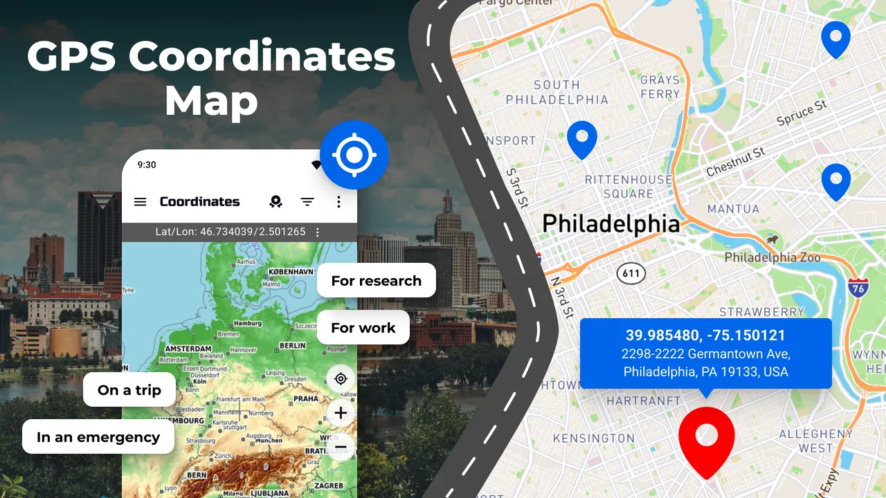
The central capability is straightforward: the app displays my GPS location on a map using coordinates. The important distinction is that it does not make me think only in terms of a named road, business, or landmark. It gives me a precise geographic reference that I can inspect while looking at the surrounding map.
That is particularly useful in places where addresses are vague or not useful. A trail entrance, an open field, a beach access point, a temporary outdoor event, or a rural property may be easy to recognize visually but difficult to describe with a normal address. In those situations, coordinates give me a compact way to identify the spot.
I also found the capability useful when two people are looking at the same area but using different landmarks. “Near the large parking area” can mean several things. A coordinate gives both people a shared reference, provided they understand how to use it. The app is most valuable when location itself is the information I need, not merely a step toward navigation.
This emphasis also makes the app less distracting than a full navigation suite. A large mapping platform usually tries to do many things at once: search businesses, calculate routes, estimate arrival times, show traffic, recommend places, and provide saved content. Those tools are excellent when I am going somewhere. GPS Coordinates Locator Map is more focused when I am already somewhere and want to understand or communicate that position.
Reading the map without treating it like a route planner
In everyday use, I would open the app after arriving at a location, allow the map to show my position, and use the displayed coordinates as a reference. The map context matters because bare numbers are hard to interpret on their own. Seeing the point in relation to roads, paths, coastlines, buildings, or open space helps me check whether the result makes sense.
That visual check is an underrated part of the workflow. If I am standing beside a road but the map appears to place me across a river or far from the visible path, I know to pause before sharing the location. GPS readings can vary with surroundings, and a map view gives me a chance to notice an obvious mismatch rather than trusting numbers blindly.
I would also use the app as a quick coordinate reader when someone asks me where I am in a place that lacks a clear address. Rather than describing several turns, I can provide a location reference and let the other person decide how to use it. This is more practical for people who are comfortable with coordinates than for someone who expects a conventional street name.
A realistic outdoor handoff
Imagine meeting a friend at a large park for a picnic. The park has several entrances, scattered paths, and more than one open area that looks suitable. If I arrive first, I can check my position in the app and send the coordinate reference instead of writing a long description involving a bench, a tree, and a path intersection. My friend can then compare that point with the map they already use.
The trade-off is that coordinates are not automatically a complete meeting plan. I still need to explain whether the point is reachable from a road, whether there is a visible landmark, and whether the other person should approach from a particular entrance. The app helps me make the location precise, but it does not replace common-sense instructions.
That is one of the most useful ways to think about it: GPS Coordinates Locator Map handles the exact “where,” while another tool or a short message may still be needed for the “how do I get there?”
Three practical habits that make the feature more useful
First, I would check the map context before sharing a coordinate. A number can look authoritative even when the phone’s position is not ideal. Looking at nearby roads and landmarks helps catch mistakes and gives the recipient a visual clue.
Second, I would pair the coordinate with a plain-language description whenever the location is important. “At the north entrance, beside the gravel lot” is more useful than a coordinate alone. The app provides precision; a short description provides confidence.
Third, I would treat the app as a reference tool rather than assuming it is a complete emergency solution. If someone is lost or in danger, the coordinate may be helpful, but the person should also communicate clearly with the relevant emergency or support service. A location display is not the same thing as a rescue workflow, live tracking system, or guaranteed communication channel.
These habits sound basic, but they prevent the most common mistake with coordinate apps: assuming that a precise-looking value automatically guarantees a precise real-world outcome.
You May Also Like

 Samsung Music
’s Quiet Strength Is Playing What You Already Own
Its reach comes less from spectacle than from dependable access to a personal library. That simplicity is both the app’s strongest retention engine and its ceiling.

 AccuWeather: Weather Radar
AccuWeather Review: A Quick, Clear Forecast for Everyday Decisions
For everyday plans, the best forecast is the one you can understand quickly. AccuWeather makes rain timing, radar, and local conditions easy to act on, with a few trade-offs.

 Hill Climb Racing
Why Hill Climb Racing Still Turns Crashes Into One More Run
A tiny car, a bumpy hill and one more upgrade: Hill Climb Racing keeps resurfacing because its simple chaos makes every near-miss feel personal.

 AliExpress - Shopping App
AliExpress Makes Global Shopping Feel Personal, but Shoppers Bear the Risk
AliExpress turns a global marketplace into a pocket-sized discovery engine. Its reach is useful, its shopping loop compelling, and its trade-offs easy to miss.

 Lords Mobile: Kingdom Wars
Lords Mobile Is a Kingdom-Building Routine, Not a Quick Match
A case-by-case verdict on the building, battles, device demands, and social commitments that make Lords Mobile rewarding for some players and exhausting for others.

 PDF Scanner app - TapScanner
TapScanner Makes Paperwork Easier to Capture, Check, and Share
TapScanner makes scanning with a phone feel less like a rescue operation and more like a dependable step in getting work done. Its capture tools are useful, though not flawless.
More From Our News Desk



How it fits into normal Android use
The app’s store summary describes its purpose clearly: displaying GPS location on a map using a GPS Coordinates app for Android. In practice, that narrow design is both its strength and its limitation. I can understand the main reason for opening it almost immediately, but I should not expect the broad set of services found in a full navigation platform.
For a quick check, the workflow is easier to understand than a route-planning screen filled with search boxes and travel options. I am not choosing a destination or comparing routes. I am looking at my current position and interpreting it. That makes it suitable for a short, deliberate task rather than continuous navigation.
People often ask whether an app like this can replace their usual map application. In my view, it cannot, and it does not need to. A standard map app is better for finding an address, choosing a route, checking traffic, or navigating through unfamiliar streets. This app is better when I want the coordinate representation of my position to be visible and central.
It is also worth asking whether it is useful only for hikers or technical users. I do not think so. Outdoor users are an obvious audience, but the same capability can help with property visits, field work, photography locations, deliveries to informal sites, event setup, and meeting people in large spaces. The common thread is that a normal address is incomplete or inconvenient.
At the same time, I would skip it if my only requirement is everyday driving directions. Installing a dedicated coordinate display for that purpose adds another step without improving the basic experience. If I am going to a restaurant, airport, shop, or hotel, a conventional navigation app is usually the more efficient choice.
What the popularity tells me, and what it does not
The app’s reach is notable: it has more than 10 million installs, while its 4.5 average comes from roughly 62 thousand ratings. Those figures tell me that many Android users find value in a focused GPS location tool. They do not mean it will suit every mapping habit, because a strong rating cannot turn a specialized utility into a full navigation replacement.
The age rating is Everyone, which fits the straightforward nature of the task. I would still explain the app to less technical family members before asking them to use coordinates. The interface may be simple to understand, but geographic coordinates are not familiar to everyone, and the surrounding map is important for interpreting them correctly.
Firehawk’s app is free to install, which makes trying the basic concept low-risk. There are in-app purchases priced from $0.99 to $99.99 per item, so I would review any purchase screen carefully and decide whether an optional addition genuinely improves my use case. For occasional location checks, I would not assume that paying is necessary before I had tested the free experience.
Where it can save time
The biggest time saving comes from avoiding a translation between a real place and an address. When I am standing somewhere without a clear postal label, I do not have to search for the nearest named feature and hope that it identifies the right spot. I can start with the position on the map and then add context.
This is especially helpful when organizing work outdoors. Suppose I am meeting someone at a temporary setup area or checking a point on a large property. A coordinate can be written down or passed along as a reference, while the map helps me verify the surrounding layout. That is more repeatable than relying on memory or a description that depends on objects that may move.
Another useful workflow is documenting a place for my future self. If I find a viewpoint, access point, or parking location that I want to revisit, I can record the coordinate with a note about what I saw there. The app supplies the location reference, while my note supplies the human detail. Together, they are more dependable than saving a vague phrase such as “turn after the old building.”
I would not treat this as a substitute for a dedicated field-mapping system when professional surveying, shared project layers, or structured records are required. Its value is in quick, personal, understandable location checks rather than in becoming a complete geographic information platform.
The limitations I noticed in the concept
The first limitation is the learning curve around coordinates themselves. Experienced users may find them natural, but many people communicate through addresses and landmarks. If I send only a coordinate to a friend, I may create confusion rather than solve it. The recipient needs a compatible map workflow and enough context to know what the point represents.
The second limitation is that a displayed GPS position should not be mistaken for survey-grade accuracy. Buildings, trees, terrain, and the general conditions around a phone can affect location readings. The sensible approach is to use the map as a plausibility check, wait if the position appears inconsistent, and avoid claiming more precision than the situation supports.
The third limitation is scope. A coordinate-focused map does not automatically provide the convenience of a mature navigation ecosystem. If I need route choices, traffic awareness, business information, public transport planning, or detailed travel guidance, my usual map service is likely to be better.
There is also a communication trade-off. Coordinates are wonderfully compact, but they are not very descriptive. They tell me where a point is, not whether the ground is accessible, whether a gate is locked, or which side of a building I should approach. I still need to combine the app with observation and clear language.
For that reason, I would be cautious about using a single coordinate as the only instruction for a time-sensitive meeting. I would send the point together with an entrance, landmark, and fallback plan. The app improves precision, but it cannot remove the real-world uncertainty around access and visibility.
Who gets the most from this focused tool
I think the strongest audience includes casual outdoor users, travelers visiting places without dependable addresses, photographers returning to a particular spot, and anyone who regularly meets people in broad public areas. It can also help people who need to communicate a location to someone using a different map service, because the coordinate is less dependent on a particular business listing or local naming convention.
It is a good fit for someone who wants a dedicated, uncomplicated way to inspect their GPS position without opening a much larger navigation application. The free entry point makes it easy to test, and the Everyone rating makes its intended audience broad.
I would be less enthusiastic for a person who wants one app to manage every aspect of travel. Drivers, commuters, delivery workers, and tourists who need route instructions may find a general navigation app more practical. Likewise, professionals who need layered mapping, formal measurement, or team-based field records should look for a specialized tool built around those tasks.
The app’s current version is 3.1.0, and it supports Android 5.0 or later, so compatibility is not limited to recent Android hardware. That can be useful if I am working with an older spare phone outdoors, although the quality of the location experience will still depend on the device and its surroundings rather than on the app alone.
My recommendation after using it
GPS Coordinates Locator Map succeeds because it does not hide its main purpose behind a complicated travel workflow. It gives GPS coordinates a visible place on a map, and that is genuinely useful when an address is missing, ambiguous, or less convenient than a geographic point.
I would recommend it as a companion to a normal navigation app, not as a replacement for one. My practical setup would be to use this app when I need to inspect or communicate a position, then rely on my regular map service for directions and route decisions. That division of labor keeps each tool doing what it handles best.
The most important thing to remember is that a coordinate is a precise reference, not a complete explanation. Check the point against the map, add a landmark or access note, and avoid treating the displayed position as infallible. Used that way, Firehawk’s app becomes a small but dependable utility for situations where “I’m near here” is not accurate enough.
For me, that focused capability is enough to justify keeping it available. It will not be the app I open for every journey, but when I need the exact location of a place that does not have a useful address, it turns a vague meeting point into a shareable geographic reference. That is a modest feature, yet in the right situation it saves time and prevents misunderstandings.
FAQs for GPS Coordinates Locator Map
01What features does the GPS Coordinates Locator Map offer?
The GPS Coordinates Locator Map provides real-time location tracking, precise coordinate information, and offline map access. It also includes features like route planning, distance measurement, and sharing location details with friends. The app is compatible with both Android and iOS, making it versatile for various user needs.
02How accurate is the GPS Coordinates Locator Map?
The app utilizes advanced GPS technology to deliver highly accurate coordinates, typically within a few meters. However, the accuracy can be influenced by factors such as device hardware, environmental conditions, and signal strength, particularly in remote or densely populated urban areas.
03Is an internet connection required to use the app?
While the GPS Coordinates Locator Map can function offline by using pre-downloaded maps, certain features like real-time location sharing and updates require an internet connection. Users can download maps for offline use, which is useful for areas with limited connectivity.
04How does the app ensure user privacy and data security?
The app prioritizes user privacy by using encrypted data transmission and offering options to control data sharing settings. It does not store personal location data on its servers, ensuring that users’ coordinates and travel history remain confidential and secure.
05What devices are compatible with the GPS Coordinates Locator Map?
The app is designed for both Android and iOS platforms, supporting a wide range of smartphones and tablets. It requires a device with GPS capability and is optimized for the latest operating systems to ensure smooth performance and access to all features.
Pros
- Accurate real-time location tracking.
- User-friendly interface and design.
- Low battery consumption mode.
- Offline maps available for remote areas.
- Customizable map views and themes.
Cons
- Requires constant GPS access.
- Ads can be intrusive at times.
- Limited features in free version.
- Occasional map loading delays.
- In-app purchases can be pricey.

GPS Coordinates Locator Map
Gallery